Portraits Of Birds By Laila Jeffreys


Portraits of birds by Laila Jeffreys
More Posts from Evisno and Others
A little more help for focusing-on beginers: In terms of cognitive demand, it is more difficult to focusing on your ongoing task when you have a long to-do list than when only a few more tasks left. So I recommend you to try making schedule with less than 5 tasks a day. It will be much easier to organize work of different fields or of different shades of cognitive demand.
How focusing (aka. not multi-tasking) changed my study life
I had heard it occasionally - that multi-tasking was actually not good for the quality of whatever task I was doing. It made sense, but I loved mult-tasking so much. It gave me the illusion of productivity.
Until I actually tried focusing for a while, did I realise how much I was actually losing by multi-tasking - educationally and emotionally. Scrolling through tumblr during boring parts of a lecture seemed fine, since there were notes and it probably wouldn’t be tested in such depth anyway. Eating, while scrolling through social media, while watching a tv show, while messaging someone on facebook seemed ‘productive’.
It turns out it was the opposite. It may seem fine, and at times it may actually be okay, but what matters is the principle. Dedicating your whole being to one task, focusing on it, produces much better results. It’s a quality over quantity thing. It also helped to calm me down emotionally - I used to always feel rushed, like there was so many things to do but not enough time to do them. Focusing on one task at a time - though it was hard at first - helped slow me down because I did everything properly, and didn’t have the feeling like I needed to go back and do things over again.
Focusing on one thing wholly is also a form of practising mindfulness. Mindfulness ‘meditation’ isn’t something that requires you to sit down and meditate - it can be applied to our daily life.
Since I started practising this mindful skill of focus, I’ve become much calmer, it’s been so much easier to stay on top of my work load and meet deadlines, I don’t feel rushed, I don’t feel unprepared or unorganised, and I do more quality work than when I used to multi-task.
There are times for multi-tasking and times for focus. Find the right balance and enjoy the task in front of you.
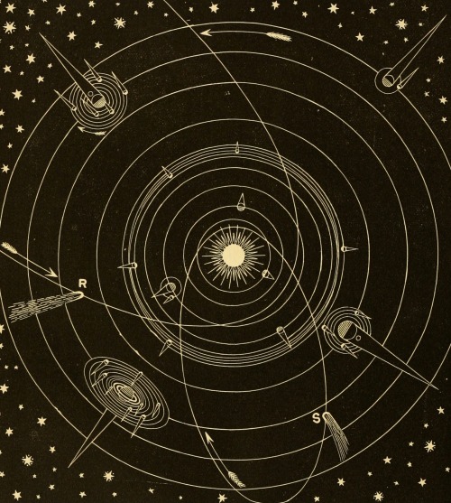
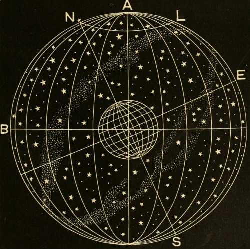
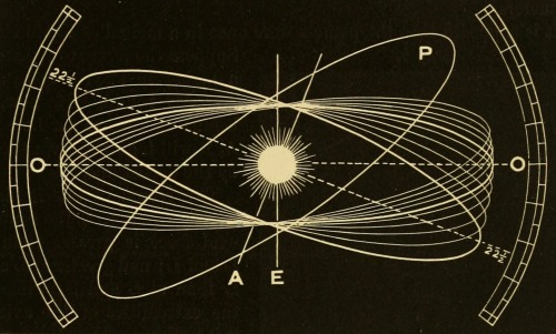
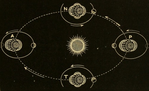
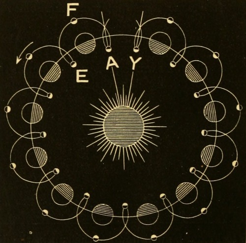
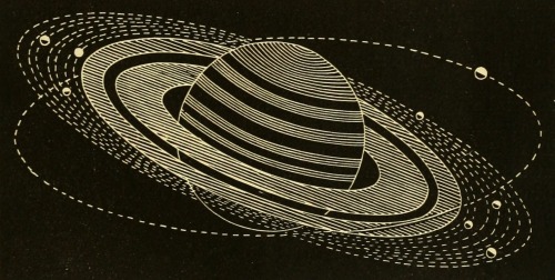
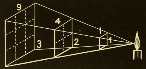
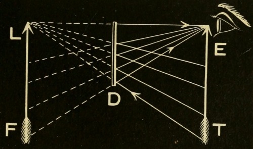
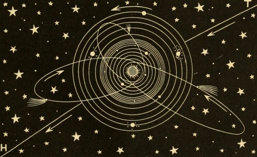

Frank G. Johnson. Solar System, Celestial and Terrestrial Latitude, The Ecliptic, Spring and Neap Tides, The Moon’s Path Around the Sun, Saturn’s Rings, Intensity of Light at Different Distances, The Optics of Plane Mirrors, The Orbit of the Sun, Method of Adjusting the Pupil or Aperture of the Eye. Johnson’s Natural Philosophy, and Key to Philosophical Charts. 1872.


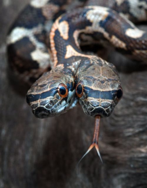


Polycephaly is the condition of having more than one head. Two-headed animals (called bicephalic or dicephalic) and three-headed (tricephalic) animals are the only type of multi-headed creatures seen in the real world, and form by the same process as conjoined twins from monozygotic twin embryos.
While two headed snakes are rare, they do occur in both the wild and in captivity at a rate of about 1 in 10,000 births. Most wild polycephalic snakes do not live long, but some captive individuals do. A two-headed black rat snake with separate throats and stomachs survived for 20 years.
(Sources: x x x x x x x x)


Window phone concept
Is it a window, is it a phone? No. Actually, it’s Window phone and this is the part where you are saying “Whaaat? What are you talking about?”. The phone is actually a concept with extraordinary features. Surely if this could be actually put into production, it would set a new standard for the term “cool”.


Jupiter’s Galilean Moons
Io - Jupiter’s volcanic moon
Europa - Jupiter’s icy moon
Ganymede - Jupiter’s (and the solar system’s) largest moon
Callisto - Jupiter’s heavily cratered moon
Made using: Celestia, Screen2Gif & GIMP Based on: @spaceplasma‘s solar system gifs Profile sources: http://solarsystem.nasa.gov/planets, http://nssdc.gsfc.nasa.gov/planetary/factsheet/joviansatfact.html


The Van Allen Belt & the South Atlantic Anomaly
NASA’s first satellite, launched in 1958, discovered two giant swaths of radiation encircling Earth. Five decades later, scientists are still trying to unlock the mysteries of these phenomena known as the Van Allen belt. The belt is named after its discoverer, American astrophysicist James Van Allen.
The near-Earth space environment is a complex interaction between the planet’s magnetic field, cool plasma moving up from Earth’s ionosphere, and hotter plasma coming in from the solar wind. This dynamic region is populated by charged particles (electrons and ions) which occupy regions known as the plasmasphere and the Van Allen radiation belt. As solar wind and cosmic rays carry fast-moving, highly energized particles past Earth, some of these particles become trapped by the planet’s magnetic field. These particles carry a lot of energy, and it is important to mention their energies when describing the belt, because there are actually two distinct belts; one with energetic electrons forming the outer belt, and a combination of protons and electrons creating the inner belt. The resulting belts, can swell or shrink in size in response to incoming particles from Earth’s upper atmosphere and changes in the solar wind. Recent studies suggest that there is boundary at the inner edge of the outer belt at roughly 7,200 miles in altitude that appears to block the ultrafast electrons from breaching the invisible shield that protects Earth.
Earth’s magnetic field doesn’t exactly line up with the planet’s rotation axis, the belts are actually tilted a bit. Because of this asymmetry, one of the shields that trap potentially harmful particles from space dips down to 200 km (124 mi) altitude.

This dip in the earth’s magnetic field allows charged particles and cosmic rays to reach lower into the atmosphere. Satellites and other low orbiting spacecraft passing through this region of space actually enter the Van Allen radiation belt and are bombarded by protons. Exposure to such radiation can wreak havoc on satellite electronics, and pose serious health risks to astronauts. This peculiar region is called the South Atlantic Anomaly.
Credit: NASA/ESA/M. Kornmesser


N44C nebula
On the middle left of the image is a source of its artistic likeness, a network of nebulous filaments surrounding the Wolf-Rayet star. This type of rare star is characterized by an exceptionally vigorous “wind” of charged particles. The shock of the wind colliding with the surrounding gas causes the gas to glow.
The Wolf-Rayet star is part of N44C, a nebula of glowing hydrogen gas surrounding young stars in the Large Magellanic Cloud. Visible from the Southern Hemisphere, the Large Magellanic Cloud is a small companion galaxy to the Milky Way.
What makes N44C peculiar is the temperature of the star that illuminates it. The most massive stars — those that are 10 to 50 times more massive than the Sun — have maximum temperatures of 30,000 to 50,000 degrees Celsius (54,000 to 90,000 degrees Fahrenheit). The temperature of this star is about 75,000 degrees Celsius (135,000 degrees Fahrenheit). This unusually high temperature may be due to a neutron star or black hole that occasionally produces X-rays but is now inactive.
N44C is part of a larger complex that includes young, hot, massive stars, nebulae, and a “superbubble” blown out by multiple supernova explosions. Part of the superbubble is seen in red at the very bottom left of the Hubble image.
Credit: NASA/JPL/Hubble

The making of Polylion


Comet ISON appears to have broken up and mostly evaporated as it travelled around the Sun, but something has made it around. It will be seen how much and in what condition. (Source of images) UPDATE: It is now confirmed that the comet is gone. Rest in pieces, ISON!
Celebrating 17 Years of NASA’s ‘Little Earth Satellite That Could’
The satellite was little— the size of a small refrigerator; it was only supposed to last one year and constructed and operated on a shoestring budget — yet it persisted.
After 17 years of operation, more than 1,500 research papers generated and 180,000 images captured, one of NASA’s pathfinder Earth satellites for testing new satellite technologies and concepts comes to an end on March 30, 2017. The Earth Observing-1 (EO-1) satellite will be powered off on that date but will not enter Earth’s atmosphere until 2056.
“The Earth Observing-1 satellite is like The Little Engine That Could,” said Betsy Middleton, project scientist for the satellite at NASA’s Goddard Space Flight Center in Greenbelt, Maryland.
To celebrate the mission, we’re highlighting some of EO-1’s notable contributions to scientific research, spaceflight advancements and society.
Scientists Learn More About Earth in Fine Detail

This animation shifts between an image showing flooding that occurred at the Arkansas and Mississippi rivers on January 12, 2016, captured by ALI and the rivers at normal levels on February 14, 2015 taken by the Operational Land Imager on Landsat 8. Credit: NASA’s Earth Observatory
EO-1 carried the Advanced Land Imager that improved observations of forest cover, crops, coastal waters and small particles in the air known as aerosols. These improvements allowed researchers to identify smaller features on a local scale such as floods and landslides, which were especially useful for disaster support.

On the night of Sept. 6, 2014, EO-1’s Hyperion observed the ongoing eruption at Holuhraun, Iceland as shown in the above image. Partially covered by clouds, this scene shows the extent of the lava flows that had been erupting.
EO-1’s other key instrument Hyperion provided an even greater level of detail in measuring the chemical constituents of Earth’s surface— akin to going from a black and white television of the 1940s to the high-definition color televisions of today. Hyperion’s level of sophistication doesn’t just show that plants are present, but can actually differentiate between corn, sorghum and many other species and ecosystems. Scientists and forest managers used these data, for instance, to explore remote terrain or to take stock of smoke and other chemical constituents during volcanic eruptions, and how they change through time.
Crowdsourced Satellite Images of Disasters

EO-1 was one of the first satellites to capture the scene after the World Trade Center attacks (pictured above) and the flooding in New Orleans after Hurricane Katrina. EO-1 also observed the toxic sludge in western Hungary in October 2010 and a large methane leak in southern California in October 2015. All of these scenes, which EO-1 provided quick, high-quality satellite imagery of the event, were covered in major news outlets. All of these scenes were also captured because of user requests. EO-1 had the capability of being user-driven, meaning the public could submit a request to the team for where they wanted the satellite to gather data along its fixed orbits.

This image shows toxic sludge (red-orange streak) running west from an aluminum oxide plant in western Hungary after a wall broke allowing the sludge to spill from the factory on October 4, 2010. This image was taken by EO-1’s Advanced Land Imager on October 9, 2010. Credit: NASA’s Earth Observatory
Artificial Intelligence Enables More Efficient Satellite Collaboration

This image of volcanic activity on Antarctica’s Mount Erebus on May 7, 2004 was taken by EO-1’s Advanced Land Imager after sensing thermal emissions from the volcano. The satellite gave itself new orders to take another image several hours later. Credit: Earth Observatory
EO-1 was among the first satellites to be programmed with a form of artificial intelligence software, allowing the satellite to make decisions based on the data it collects. For instance, if a scientist commanded EO-1 to take a picture of an erupting volcano, the software could decide to automatically take a follow-up image the next time it passed overhead. The Autonomous Sciencecraft Experiment software was developed by NASA’s Jet Propulsion Laboratory in Pasadena, California, and was uploaded to EO-1 three years after it launched.

This image of Nassau Bahamas was taken by EO-1’s Advanced Land Imager on Oct 8, 2016, shortly after Hurricane Matthew hit. European, Japanese, Canadian, and Italian Space Agency members of the international coalition Committee on Earth Observation Satellites used their respective satellites to take images over the Caribbean islands and the U.S. Southeast coastline during Hurricane Matthew. Images were used to make flood maps in response to requests from disaster management agencies in Haiti, Dominican Republic, St. Martin, Bahamas, and the U.S. Federal Emergency Management Agency.
The artificial intelligence software also allows a group of satellites and ground sensors to communicate and coordinate with one another with no manual prompting. Called a “sensor web”, if a satellite viewed an interesting scene, it could alert other satellites on the network to collect data during their passes over the same area. Together, they more quickly observe and downlink data from the scene than waiting for human orders. NASA’s SensorWeb software reduces the wait time for data from weeks to days or hours, which is especially helpful for emergency responders.
Laying the Foundation for ‘Formation Flying’

This animation shows the Rodeo-Chediski fire on July 7, 2002, that were taken one minute apart by Landsat 7 (burned areas in red) and EO-1 (burned areas in purple). This precision formation flying allowed EO-1 to directly compare the data and performance from its land imager and the Landsat 7 ETM+. EO-1’s most important technology goal was to test ALI for future Landsat satellites, which was accomplished on Landsat 8. Credit: NASA’s Goddard Space Flight Center
EO-1 was a pioneer in precision “formation flying” that kept it orbiting Earth exactly one minute behind the Landsat 7 satellite, already in orbit. Before EO-1, no satellite had flown that close to another satellite in the same orbit. EO-1 used formation flying to do a side-by-side comparison of its onboard ALI with Landsat 7’s operational imager to compare the products from the two imagers. Today, many satellites that measure different characteristics of Earth, including the five satellites in NASA’s A Train, are positioned within seconds to minutes of one another to make observations on the surface near-simultaneously.
For more information on EO-1’s major accomplishments, visit: https://www.nasa.gov/feature/goddard/2017/celebrating-17-years-of-nasa-s-little-earth-satellite-that-could
Make sure to follow us on Tumblr for your regular dose of space: http://nasa.tumblr.com/.
-
 raining-peonies liked this · 9 months ago
 -
 daieuxetdailleurs liked this · 1 year ago
 -
 fomikrai liked this · 2 years ago
 -
 anynameisbetterthanmyfirstone liked this · 3 years ago
 -
 technoglyph reblogged this · 4 years ago
 -
 kaifyer reblogged this · 7 years ago
 -
 stormphoenix reblogged this · 7 years ago
 -
 theticklefox-blog liked this · 7 years ago
 -
 lady-adrian-dangerous reblogged this · 7 years ago
 -
 azure-prince liked this · 9 years ago
 -
 mothmeats reblogged this · 9 years ago
 -
 sam-deleon reblogged this · 9 years ago
 -
 personalshrines reblogged this · 9 years ago
 -
 remenoir reblogged this · 9 years ago
 -
 quakersgonaquake-blog reblogged this · 9 years ago
 -
 havenontrack liked this · 9 years ago
 -
 foxmonkey liked this · 9 years ago
 -
 pinkpalinode reblogged this · 10 years ago
 -
pinkpalinode liked this · 10 years ago
-
 bodoblack liked this · 10 years ago
 -
 spxders-prxy-blog liked this · 10 years ago
 -
 archivedectopicfantast reblogged this · 10 years ago
 -
 saintdenial reblogged this · 10 years ago
 -
 the-sleepy-seal reblogged this · 10 years ago
 -
 exxemplary-archived reblogged this · 10 years ago
 -
 aprimreaper reblogged this · 10 years ago
 -
 bloodfestbutterfly reblogged this · 10 years ago
 -
oto126 liked this · 10 years ago
-
 space1234 liked this · 10 years ago
 -
f-u-c-k-you-t-u-m-b-l-r reblogged this · 10 years ago
-
f-u-c-k-you-t-u-m-b-l-r liked this · 10 years ago
-
 lavolvacreates liked this · 10 years ago
 -
 coldforest liked this · 10 years ago
 -
 ilovedeonte-blog liked this · 10 years ago
 -
 shetmunch reblogged this · 10 years ago
 -
 mlier reblogged this · 10 years ago
 -
 superhydrophobe reblogged this · 10 years ago