The Most Metal Mass Extinction Events, Ranked
The Most Metal Mass Extinction Events, Ranked
in the style of The Toast
That One Unnamed Extinction Event That Happened When Blue-Green Algae Discovered Photosynthesis and Started Pumping the Environment Full of Oxygen, Which Was Toxic to All Other Life on Earth at That Point in Time
This extinction event did result in the extinction of more living organisms than any other, whether you rank by number of individuals, number of orders/genera/species, % of life, or amount of biomass, but they were all single-celled organisms, so they don’t even register on the metal scale.
The Current Slow Slide Due to Anthropogenic Environmental Modification
Habitat destruction isn’t very metal.
Late Devonian
Some super-weird shit died out, which is totally metal, but we have no idea why, which isn’t. It might not even have been an extinction event, just a decrease in the speciation rate. Jawed vertebrates totally unaffected.
End Ordovician
Second-largest extinction event after the End Permian (not counting those blue-green algae fuckers). Caused by tectonic plate shifting (kinda metal) and resulting glaciation (mildly metal).
Deep Impact
Pros: Giant asteroid hitting the earth.
Cons: Fictional.
End Triassic
Probably caused by massive volcanic eruptions, which is pretty metal, but mostly just wiped out some weird looking amphibians, which is only mildly metal.
End Permian
Greatest extinction event of all time (with the exception of that blue-green algae fiasco mentioned above), wiping out ~95% of all species: metal. Only known mass extinction of insects: metal. Probably caused by the biggest volcanic eruptions since life began (metal) which ignited massive coal beds (metal) and caused the release of methane from the ocean floor (metal) resulting in a runaway greenhouse effect that raised the average ocean temperature to 40C for several million years, essentially boiling the earth alive (super metal). Paved the way for dinosaurs to take over the earth: metal. Known as the ‘Great Dying’: totally metal.
However, most of the extinctions occurred in sessile marine organisms, which are way too boring to be metal, and for the first ~20 million years after the extinction event, land was dominated by Lystrosaurus, which is the most un-metal looking reptile you can think of.
End Cretaceous, aka the K-T Event
A GIANT FLAMING BALL OF ROCK HIT THE EARTH AND KILLED ALL THE (non-avian) DINOSAURS. ENOUGH SAID.
More Posts from Dotmpotter and Others

New interactive map shows how rising seas will swallow US cities
While there’s unarguably greater awareness than ever that man-made climate change is contributing to global warming and rising sea levels, it can be difficult to visualise what that exactly means for the city you live in. How high will sea levels rise? When will it happen? Where will it happen? And, most importantly, what can we do about it?
These are the questions that this stunning new interactive map is designed to get you thinking about. Mapping Choices is part Google Maps, part time machine. It lets you choose any US city or zip code to see what rising seas will do to your nominated address, based on a range of projections about how high sea levels could increase.
- ScienceAlert

Map of Australia with a so called ‘remoteness index’, illustrating how far locations in Australia are from population centers [999x766] CLICK HERE FOR MORE MAPS! thelandofmaps.tumblr.com
You're only an "economic migrant" if you're poor and brown

Ned Richardson-Little is a Canadian academic who went to the US “in search of a better life,” did research in Germany and settled in the UK, something he was able to do thanks to his economic migrant grandfather who happened to have been born in Scotland.
Richardson contemplates the vilified category of “economic migrant” – “the greedy, dark other to those virtuously fleeing conflict” – and wonders how it is that no one has ever vilified him, given that he, too, is so obviously an “economic migrant.”
My grandparents (and father) were displaced people – Red Army deserters who destroyed their papers so that they could escape Europe via the DP boats to Canada – and I left Canada for the USA to found a company, then moved to the UK to represent an NGO and became a citizen, and have now moved back to the USA to write novels and campaign for better information policy. No one has ever called me an economic migrant.
https://boingboing.net/2015/11/29/youre-only-an-economic-mig.html


New book on the Halley VI Research Center. Halley VI is a string of 8 modules located on the Brunt Ice Shelf floating on the Weddell Sea in Antarctica. These sexy buildings are built on skis to help them move around. Check out the book, here.

In the San Joaquin Valley, a legacy of shortsighted land-use planning has intensified the water crisis for poor residents.
[Image: Laura Bliss/CityLab]
Meet Hannah Herbst, a 15-year-old from Boca Raton, Florida, who just might be the nation’s top young scientist. Earlier this month, Herbst won a $25,000 prize with a very cheap invention: a prototype probe that converts the movement of the ocean’s currents into energy and costs just $12 to make. Out of nine other middle-school finalists, Herbst was awarded first place in the 2015 Discovery Education 3M Young Scientist Challenge.
This 15-Year-Old’s Invention Converts Ocean Currents Into Energy—for Cheap | GOOD


New 3-D Printer Produces Delicate Soft Objects
A new method of depositing drops of soft materials in a gel could be a new way to print squishy three-dimensional products like living tissue, soft robots and flexible electronics.
In the technique created by University of Florida researchers, a computer-controlled hollow tip precisely embeds fluid droplets of silicone, hydrogel, colloids or living cells inside a granular medium bath the consistency of hand sanitizer. After using the method to make tiny complex soft structures like delicate jellyfish, a tubular knot and a gel version of the nested shapes called Russian dolls, the group says they might have created a new era for engineering.
Keep reading

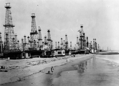


Drilling for oil on Venice Beach | Via
Native Americans first discovered oil in California, as it seeped to the surface of the earth. They used it as a lubricant and sealant for canoes. It was later used for similar purposes by Spanish colonizers.
As the state’s population boomed in the decades following the gold rush of 1849, there was a rapidly growing demand for petroleum.
Drilled in 1876, the first commercially successful oil well in California was Well No. 4 in the Pico Canyon Oilfield in the Santa Susana Mountains.
More discoveries followed, from the Los Angeles City Oil Field in 1892 to Huntington Beach in 1920 and Long Beach in 1921.
By 1920, California was producing 77 million barrels of oil a year, and vast stretches of the state were occupied by derricks, drilling rigs and refineries.
In places such as Venice, California (now known as Marina del Rey), oil derricks ran right up to the shore, mingling with residential neighborhoods and pristine beaches.
TED Grant Goes to Archaeologist Who Combats Looting With Satellite Technology

Her laptop brims with satellite images pitted with thousands of black dots, evidence of excavations across Egypt where looters have tunneled in search of mummies, jewelry and other valuables prized by collectors, advertised in auction catalogs and trafficked on eBay, a criminal global black market estimated in the billions of dollars.
“For the first time technology has gotten to the point where we can map looting,” said Sarah H. Parcak, a pioneering “space archaeologist,” founding director of the University of Alabama’s Laboratory for Global Observation in Birmingham and an associate professor there.
Satellite eyes in the sky, which have transformed the worldwide search for buried archaeological treasures, are now being used to spy on the archenemies of cultural preservation: armies of looters who are increasingly pockmarking ancient sites with illicit digs and making off with priceless patrimony. Read more.
-
 pickledpopcorn reblogged this · 1 year ago
 -
 automatic-panda liked this · 1 year ago
 -
 happyorogeny reblogged this · 2 years ago
 -
 sapphiresingularity reblogged this · 2 years ago
 -
sapphiresingularity liked this · 2 years ago
-
 unrealcities reblogged this · 2 years ago
 -
 ellasadventuresinfandoms reblogged this · 2 years ago
 -
ellasadventuresinfandoms liked this · 2 years ago
-
unrealcities liked this · 2 years ago
-
 sasha-well reblogged this · 2 years ago
 -
sasha-well liked this · 2 years ago
-
 berrysphase liked this · 2 years ago
 -
 thesnug liked this · 2 years ago
 -
 angualupin reblogged this · 2 years ago
 -
 dissociating-or-just-my-reality reblogged this · 2 years ago
 -
 orion-the-onion reblogged this · 2 years ago
 -
orion-the-onion liked this · 2 years ago
-
 acrushonesmeralda reblogged this · 3 years ago
 -
 viciouscabaret-blog reblogged this · 4 years ago
 -
 calleytheginge reblogged this · 5 years ago
 -
 marashapeshifter reblogged this · 5 years ago
 -
 chaoswithinthemountain reblogged this · 5 years ago
 -
 chaifighter liked this · 5 years ago
 -
 werewolfin reblogged this · 5 years ago
 -
werewolfin liked this · 5 years ago
-
 detectiveanna reblogged this · 5 years ago
 -
detectiveanna liked this · 5 years ago
-
 gallifreyan-magics reblogged this · 5 years ago
 -
 vespertineflora reblogged this · 5 years ago
 -
 commonsunshine reblogged this · 5 years ago
 -
 nohomoyesbi reblogged this · 5 years ago
 -
nohomoyesbi liked this · 5 years ago
-
 redwoodsin reblogged this · 5 years ago
 -
redwoodsin liked this · 5 years ago
-
 sariahael reblogged this · 5 years ago
 -
sariahael liked this · 5 years ago
-
 kimbleeofficial reblogged this · 5 years ago
 -
 witchoflight liked this · 5 years ago
 -
kimbleeofficial liked this · 5 years ago
-
 cosmic-bovines reblogged this · 5 years ago
 -
 plantfae liked this · 5 years ago
 -
 me-sorta reblogged this · 5 years ago
 -
 littleandrogynousbastard liked this · 5 years ago
 -
cosmic-bovines liked this · 5 years ago