Ending Slavery Will Also Help Save The One Thing That Connects Us All... Earth.
Ending slavery will also help save the one thing that connects us all... Earth.

Read it here.
“Desperate migrants from Myanmar and Cambodia are enslaved on fishing boats to strip the oceans of fish… in Brazil, young men are trapped by debt in work illegally logging the Amazon forest… Brick kilns in India, operated by bonded labourers, are fuelled with old tyres and used motor oil, spewing carcinogens into the air.”
REBLOG to educate your community about the impact of our everyday consumption.
More Posts from Dotmpotter and Others

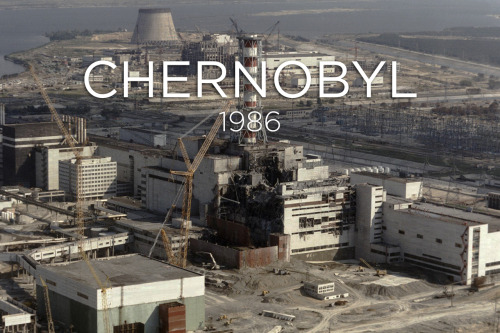
On April 26, 1986, a power surge caused an explosion at the Chernobyl Nuclear Power Plant near Pripyat, Ukraine. A large quantity of radioactive material was released.
On May 2, 1986, the Soviet government established a “Zone of Alienation” or “Exclusion Zone” around Chernobyl – a thousand square miles of “radioactive wasteland.” All humans were evacuated. The town of Pripyat was completely abandoned.
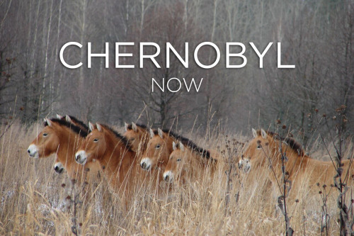
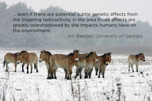
But the animals didn’t leave. And a new study, published this month in Current Biology, suggests they are doing fine. “None of our three hypotheses postulating radiation damage to large mammal populations at Chernobyl were supported by the empirical evidence,” says Jim Beasley, one of the researchers.
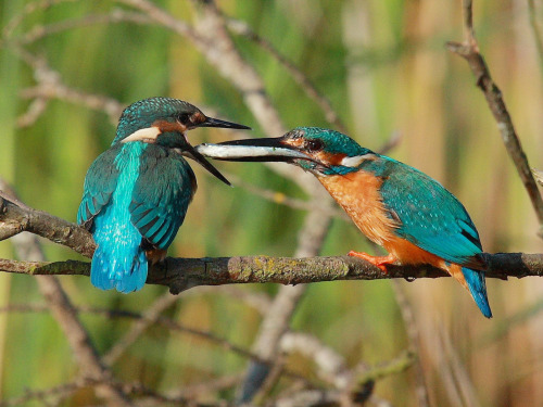
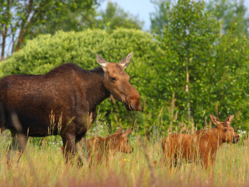
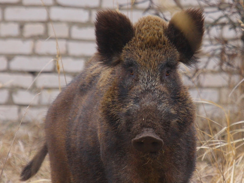
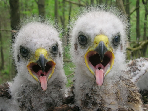
In fact, some of the populations have grown. These photos (mostly taken by Valeriy Yurko) come from the Belarusian side of the Exclusion Zone, and area called the Polessye State Radioecological Reserve. Kingfisher, elk, boar, baby spotted eagles, wild ponies, moose, rabbits, and wolves all make their home in the park. In some ways, human presence is worse for wildlife than a nuclear disaster.
Image credits:
1986 Chernobyl - ZUFAROV/AFP/Getty Images
Wildlife photos - Valeriy Yurko/Polessye State Radioecological Reserve
Ponies in winter - SERGEI SUPINSKY/AFP/Getty Images


From Hawaii’s flurry of hurricanes, to record high sea ice in Antarctica, and a heat wave that cooked the Australian Open like shrimp on a barbie, 2014 saw some wild weather. How much of that was tied to climate change is what scientists around the world tried to answer in the Bulletin of the American Meteorological Society’s annual attribution report, which was published Thursday.
What they discovered was that the clearest impacts of warming could be found in heat-related events, from heat waves on land to unusually hot ocean waters. Other events, like droughts in East Africa and the Middle East, California’s intense wildfires, and winter storms that continually swept across the eastern U.S., were harder to pinpoint. In part this is because such events are inherently complex, with a multitude of factors influencing them.
For example, while the East African drought was found to be both more likely and more intense because of warming, the situation in the Middle East was less clear, with no discernable climate change connection to the various factors that influenced it. Likewise, no direct push from climate change could be found in California’s wildfire activity, though it is clear that it is increasing the overall wildfire risk there.
And while some events, like the U.S. winter storms and the record high Antarctic sea ice extent, could be pinned to a particular cause, that cause could not be linked to climate change. For other events, like the drought in Brazil and flooding in the Canadian prairies, humans influenced the likelihood in other ways besides the greenhouse gases that continue to be emitted into the atmosphere.
What was clear, though, is that the fast-growing field of what is called extreme event attribution is gaining momentum. Researchers are casting a wider net for extreme events to examine and continually refining their methods. Attribution work has traveled a considerable distance since its inception just over a decade ago.
“Extreme event attribution” is a new topic for me. Very cool science right thar.

Iceland to Help Develop Geothermal Energy in Ethiopia
An EPIC View of Earth
“Look again at that dot. That’s here. That’s home. That’s us.”
Carl Sagan wrote those words in his book Pale Blue Dot: A Vision For The Human Future In Space. His now-famous ode to our home planet (listen to the full passage here, in animated form) is perhaps our most poignant and humble reminder of the exquisite beauty and shared fragility of this planet we call home.
NASA is now bringing us a daily reminder of that message, thanks to the EPIC camera (a very appropriately named camera, in my opinion) on board NOAA’s DSCOVR satellite. You can see some of its handiwork in the image sequence above.
DSCOVR’s official space job is to observe weather on and around the sun, to extend its mechanical finger into the solar wind and measure how strongly that stream of charged particles is gusting toward Earth. It does this job from a special spot in space called the L1 Lagrange point. If you were to draw a line between us and the sun, DSCOVR would be sitting along it, like so (not to scale):

That’s a convenient place to put a spacecraft, especially one whose job it is to stare at the sun. See, DSCOVR is nestled inside a pocket where it’s tugged equally by the Earth’s and Sun’s gravity, like a stalemate in an orbital game of tug-o-war. Gravity does all the work, and the spacecraft doesn’t need to maneuver much to stay in position. There’s a few of these gravity-neutral Lagrange points out there, as you can tell in the image above, and we’ve got spacecraft residing at all of them.
As a side effect of its sun-staring mission, DSCOVR’s backside happens to be looking back at Earth full-time. In a way, I think that makes it a different sort of moon.
NASA doesn’t like to let any opportunity go un-scienced, of course, so they decided to slap a camera on DSCOVR’s rear, the one named EPIC, and use their stable perch to keep a regular eye on us. Good lookin’ out, NASA.
A little change in perspective can do a planet good. In 1990, from a vantage point beyond Pluto, Voyager 1 turned its cameras back toward home to take one last look, giving us the image that inspired Carl Sagan’s ode to ol’ Dotty Blue:

This was not an easy shot to take. Voyager’s camera wasn’t the fancy digital type like most of us have in our phones. It was essentially an old-fashioned black and white tube TV in reverse, relying on colored filters held in front of the camera to highlight different wavelengths of light. Voyager stored its image data on magnetic tape, and each of the shots took more than five hours to reach Earth. Sagan and NASA’s planetary science team had to practically move the heavens (since they were unable to move the Earth) in order to take that picture.
Now consider the effect this picture has had. That’s home. That’s us. Even if you weren’t born in 1990, everyone and everything that made you is in and on that hazy blue speck. I hope you never lose sight of how amazing it is to view our planet from this perspective.
Luckily, you can get a reminder every day. The DSCOVR satellite is now sending roughly a picture an hour back to Earth, 24/7/365. That’s a near real-time view of our home. Go take a look. It’s pretty epic.
To see a daily look at what a day on Earth looks like, check out EPIC’s daily updates here.


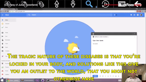

Watch the video of this man giving away his software for free to help people with degenerative diseases communicate
The World's Commercial Shipping Routes
by Grolltech on Wikipedia:

This map of shipping routes illustrates the present-day density of commercial shipping in the world’s oceans.
Via Reddit and Wikipedia, data from the National Center for Ecological Analysis and Synthesis

World Pulse, a magazine and online media nonprofit, is a place for women around the world to report on issues that are important to them.
The goal is to give all women a voice that will in turn help them improve their communities and their lives.
"We’re not about professional journalists, we’re more about that emerging woman leader who’s just coming online and has a powerful contribution to make," says founder Jensine Larson.
World Pulse’s “web” of women grows (PBS NewsHour)
my man went for it
-
 gluten-freemium liked this · 9 years ago
 -
 moples72 reblogged this · 9 years ago
 -
moples72 liked this · 9 years ago
-
 deejaythedork reblogged this · 9 years ago
 -
 iamibe reblogged this · 9 years ago
 -
iamibe reblogged this · 9 years ago
-
 dotmpotter reblogged this · 9 years ago
 -
 swimmingsunrise liked this · 9 years ago
 -
 heiferinternational liked this · 9 years ago
 -
 vertigular-is-a-word reblogged this · 9 years ago
 -
 toxic-butterfly-kisses liked this · 9 years ago
 -
 thoughtlessarse reblogged this · 9 years ago
 -
thoughtlessarse liked this · 9 years ago
-
 furbiesforfreedom liked this · 9 years ago
 -
 niarastorm reblogged this · 9 years ago
 -
niarastorm liked this · 9 years ago
-
 megantheegriffin liked this · 9 years ago
 -
 orfinned liked this · 9 years ago
 -
 waltzabovetheocean liked this · 9 years ago
 -
 orangeyounewaroundhere liked this · 9 years ago
 -
 juiceboxsteve liked this · 9 years ago
 -
 abitcoingirl-truthseeker liked this · 9 years ago
 -
 sustain-better-business liked this · 9 years ago
 -
 pbw reblogged this · 9 years ago
 -
pbw liked this · 9 years ago
-
 erickdmcorona reblogged this · 9 years ago
 -
erickdmcorona liked this · 9 years ago
-
 linger-n-exchange reblogged this · 9 years ago
 -
 africanpearl reblogged this · 9 years ago
 -
 chicaneriechic liked this · 9 years ago
 -
 madeinafreeworld reblogged this · 9 years ago